World
World
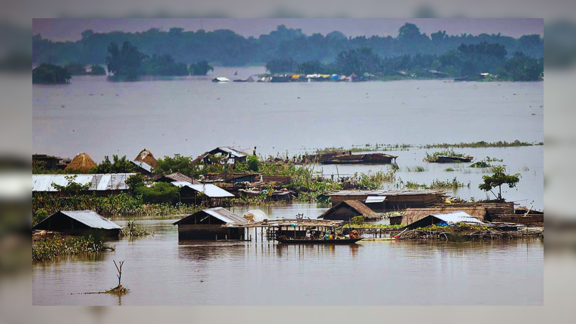
Assam has been hit by severe floods yet again. The Brahmaputra River and its tributaries cause annual flooding in the northeastern Indian state of Assam. The frequency and intensity of floods vary by year, although Assam has historically experienced substantial flooding during the monsoon season. Assam has had catastrophic floods in recent decades, including 1954, 1988, 1998, 2004, 2007, 2012, 2017, 2020, 2022, and 2023. This year is no exception. These floods have caused severe damage to infrastructure, crops, and human relocation, making flood management a crucial issue for the government.
Approximately 16.50 lakh people have been affected in 29 districts as major rivers throughout the state flow above the danger mark. This year’s death toll from floods, landslides, and storms has increased to almost 80 people, with many more reported missing. Furthermore, floodwaters have submerged around 80 percent of Kaziranga National Park, a UNESCO World Heritage site.
Every year, Assam gets hit during the monsoon. But why?
Across Assam, eleven rivers including the Brahmaputra are flowing above the danger line, flooding roads, communities, embankments, and agricultural areas.
Every year, this northeastern state experiences heavy rains. Assam contains a huge network of waterways, including the Brahmaputra and the Barak waterways, as well as 50 tributaries. The state also receives river water from the seven sisters of India, Arunachal Pradesh and Meghalaya.
According to the Assam Water Resources Ministry, the monsoon season accounts for 85 percent of total annual precipitation in the Brahmaputra basin. “Besides the valley gets a good amount of rainfall in April and May due to thunderstorm activities which account for flood during heavy rain in June, when the soil is already saturated,” says The Hindu.
Assam experiences floods due to a variety of causes, including its natural topography and high annual rainfall. Riverbank erosion is one of the causes of disastrous floods in the state. It refers to the removal of soil, sediment, or rock pieces from banks due to excessive water flow. Bank erosion has emerged as a major issue for Assam. The Brahmaputra and its tributaries have degraded more than 4.27 lakh hectares of land since 1950, according to the Assam government’s climate change report.
If we look at the man-made factors that contributed to these floods, we can see that encroachment on river banks and destruction of wetlands, deforestation, a lack of drainage, unplanned urban growth, and hill cutting have all exacerbated Assam’s flood crisis. Finally, climate change has made floods more frequent and severe in this region.
Is India highly vulnerable to floods?
India is highly vulnerable to floods. More than 40 million hectares (mha) of the overall geographical area are at risk of flooding. Floods are a recurring event that result in significant loss of life and damage to livelihood systems, property, infrastructure, and public utilities. Flood-related damages appear to be on the rise, which is concerning. The average yearly flood damage over the recent decade, from 1996 to 2005, was Rs. 4745 crore, compared to Rs. 1805 crore in the previous 53 years. This can be linked to a variety of factors, including fast urbanization, increased development and commercial activity in floodplains, and global warming.
Every year, floods affect 75 lakh hectares of land, claim 1600 lives, and incur Rs.1805 crores in damage to crops, residences, and public facilities. 1977 was the year with the most deaths (11,316). Major floods occur more than once every five years.
Floods have also occurred in areas, which were earlier not considered flood prone. An effort has been made in these Guidelines to cover the entire gamut of Flood Management. Eighty per cent of the precipitation takes place in the monsoon months from June to September. The rivers a bring heavy sediment load from catchments. These, coupled with inadequate carrying capacity of rivers are responsible for causing floods, drainage congestion and erosion of river-banks. Cyclones, cyclonic circulations and cloud bursts cause flash floods and lead to huge losses. It is a fact that some of the rivers causing damage in India originate in neighboring countries; adding another complex dimension to the problem. Floods continue to claim lives and cause significant damage to public and private property, indicating that we have yet to establish an effective response. According to the National Disaster Management Authority, the NDMA’s Executive Summary Guidelines have been developed to assist the various implementing and stakeholder agencies in efficiently addressing the essential areas for reducing flood damage.

What Causes Floods?
Inadequate capacity of the rivers to contain within their banks the high flows brought down from the upper catchment areas following heavy rainfall, leads to flooding. The tendency to occupy the flood plains has been a serious concern over the years. Because of the varying rainfall distribution, many a time, areas which are not traditionally prone to floods also experience severe inundation. Areas with poor drainage facilities get flooded by accumulation of water from heavy rainfall. Excess irrigation water applied to command areas and increase in ground water levels due to seepage from canals and irrigated fields also are factors that accentuate the problem of water-logging. The problem is exacerbated by factors such as silting of the riverbeds, reduction in the carrying capacity of river channels, erosion of beds and banks leading to changes in river courses, obstructions to flow due to landslides, synchronisation of floods in the main and tributary rivers and retardation due to tidal effects.
During floods, it’s essential to have an emergency kit ready. Include a battery-operated torch with extra batteries, a radio, and a first aid kit with necessary medicines. Pack dry food, sealed water bottles, candles, and matches in waterproof containers. Keep a knife, ropes, and sturdy shoes handy. Store important documents like Aadhar Card and ration card in a waterproof bag, along with some cash. This kit will help you stay prepared and safe during flood emergencies.
- Kerala Floods (2018): In August 2018, Kerala experienced one of its worst flood disasters in recent history. Heavy monsoon rains, exacerbated by the opening of dam reservoirs, led to massive flooding across the state. Nearly 483 people lost their lives, and over 14 lakh (1.4 million) people were displaced. The floods caused extensive damage to infrastructure, homes, agriculture, and tourism, with estimated economic losses exceeding ₹20,000 crore ($3 billion).
- Assam Floods (2020): Assam faces annual flooding due to the Brahmaputra River and its tributaries, but the floods in 2020 were particularly severe. Over 2.8 million people were affected across 5,620 villages and 30 districts. The floods claimed the lives of 128 people and displaced thousands. Agricultural lands, roads, bridges, and houses suffered extensive damage, impacting livelihoods and infrastructure.
- Chennai Floods (2015): In November-December 2015, Chennai and surrounding areas in Tamil Nadu experienced unprecedented rainfall that led to severe flooding. The city received over 1,000 mm of rain in a few days, causing rivers to overflow and inundate residential areas. The floods claimed around 500 lives and displaced thousands. Key infrastructure like roads, railways, and the airport were severely affected, disrupting normal life for weeks.
- Uttarakhand Floods (2013): In June 2013, Uttarakhand witnessed catastrophic floods and landslides triggered by heavy rainfall, cloudbursts, and glacial lake outbursts. The disaster affected the Char Dham pilgrimage sites and several towns along the Ganges and its tributaries. The floods resulted in the loss of over 5,700 lives, with thousands reported missing. Infrastructure, including roads, bridges, and buildings, was extensively damaged, leading to one of the deadliest natural disasters in India’s recent history.
These events highlight India’s susceptibility to floods, worsened by factors like rapid urbanization, deforestation, and climate change. It’s essential to focus on disaster preparedness, early warning systems, and sustainable development to reduce the impact of future floods.